News
What the BRG has been doing
EPA approves first land clearance in Banjup
In December 2024 the BRG made a submission to the Environmental Protection Authority opposing the clearing of 4.26 ha of native vegetation on part of Lot 11 Beenyup Road, Banjup, in preparation for residential development.
Disappointingly, on 13 January 2026, the EPA published its approval for Aigle Royal to clear land in Banjup for development, as shown in the graphic below.
A few years ago, Aigle Royal agreed with the City of Cockburn to gift to the City the large part of Lot 11 east to Beenyup Road, as well as the south adjacent Lot 74, because they are both wetlands and cannot be used for housing. Around that time, the City agreed to the urbanising of the dry part of Lot 11 across the boundary west into Aubin Grove. Aigle Royal have now come back for more.

The clearance is subject to an offset agreement with the City of Cockburn for the rehabilitation of a 16 hectare old sand mine site in the Rose Shanks Reserve, Treeby.
Unfortunately, the BRG did not become aware of the approval until 10 February. We were disappointed that the City of Cockburn had made no-one in Banjup aware of its own breach of the City’s Banjup Preservation Principles.
The BRG President and Secretary attended the Council meeting of 10 February to express our disappointment at the decision and to ask questions about the matter but we were cut short by the Mayor.
You might have seen in PerthNow the report about our approach to Council ( Banjup residents disappointed at agreement for urban development | PerthNow )
Clearance and development of the 4.26 hectares would be the first of any Banjup land lost to developers. It sets a worrying precedent.
Apparently, the City of Cockburn agreed to the Rose Shanks offset arrangement because the alternative offset offered by Aigle Royal was to be delivered in Beermullah, east of Guilderton and 125 km from Banjup. How the local cockatoos would find their way to that distant offset is unclear.
Reading the EPA’s assessment report (see Urban Development of lots 11 and 74 Beenyup Road Banjup | EPA Western Australia ), it would seem that for Banjup, the EPA is concerned mostly with the preservation of Banksia woodland and despoiling wetlands. However, the EPA seems open to compromise on these concerns and will trade them away for plausible offsets.
The Banjup offset arrangement will trade off 4 hectares of existing cockatoo foraging woodland for a promise of 16 hectares elsewhere in 20 years’ time.
The implications for Banjup are profound. Horse properties cleared for grazing and properties wooded mostly with gum trees could be targeted by developers, knowing that the EPA sees little environmental value in those lands. Properties significantly wooded with Banksia would be more problematic for developers.
The precedent has been set. It will need vigorous and sustained community action to assure Banjup’s survival.
Proposed City of Cockburn Local Laws out for public comment until 6 March
7 of the City of Cockburn’s local laws are being revamped. You can see their proposals at https://comment.cockburn.wa.gov.au/locallaws
There are significant changes in the local laws for fencing, nuisances, and keeping of animals.
The BRG Committee has identified a few provisions in the local laws that might need some clarification, as follows:
Keeping of Animals
Dogs – The local law follows the State’s Dog Act and describes how the City will fulfil its duties under the Act.
Cats – The local law follows the State’s Cat Act and describes how the City will fulfil its duties under the Act. However, at Schedule 6, the Local Law lists all of the Cat prohibited areas, which, in effect, seem to be all of the City’s reserves.
“A cat must not be in a cat prohibited area at any time. If a cat is in a cat prohibited area – (a) the owner of the cat commits an offence; and 15 (b) an authorised person may seize, impound and deal with the cat in accordance with the Cat Act.”
The onus is on the owner to keep their pet moggie out of Triandra, Gil Chalwell, Buckingham, Rose Shanks, etc. (The same applies for Shirley Balla except that reserve is not managed by Cockburn but by DBCA)
Large Animals (cows, horses, sheep goats, llamas, alpacas, etc) – No more than 2 such animals can be kept on a rural property without a permit. This relaxes the existing local laws which required a permit for any large animals, so this is a major change.
Poultry – No more than 30 may be kept without a permit from the City, which is up from 25 in the current local law.
Bees – 2 hives can be kept without a permit. Previously, no hives could be kept without a permit. However, they must still be registered with the Department of Agriculture.
Fencing
Electric Fence – Permit required
Barbed and Razor Wire Fences – Conditions apply
Sufficient Fence – On a rural lot (does this include the “resource zone”?) the fence must be:
-
at least 1.2m high; and
-
of a posts and wire construction.
Privacy walls near to the residence might not comply with this. However, further away post and wire would facilitate wildlife corridors.
Health and Nuisances
Assuring compliance with these conditions could be controversial:
2.5 Removal of refuse and disused materials
An owner or occupier of land must not keep, or permit to remain on the land, any refuse, rubbish or disused material which in the opinion of the local government is likely to give the land an untidy appearance and does not conform with the general appearance of other land in that particular part of the district.
2.6 Removal of unsightly growth or vegetation
The owner or occupier of a lot must not permit to remain on a lot any unsightly overgrowth of vegetation that gives the lot an untidy appearance and does not conform with the general appearance of other land in that part of the district.
2.7 Storage of vehicles and machinery
The owner or occupier of a residential lot must not –
(a) store or allow to remain on any land any vehicle or machinery (or part thereof) in a state of disrepair or disuse; or
(b) wreck, dismantle or break up any vehicle or machinery (or part thereof) unless –
(i) inside a building; or
(ii) within an area enclosed by a fence or wall not less than 1.8 metres in height and of such a nature as to screen all vehicles, parts or bodies of vehicles or machinery from the street and from adjoining land.
4.2 Flies
An owner or occupier of land must –
-
ensure that the land is kept free of waste food or other matter that is located so as to be, or
-
to be liable to become, a breeding ground or flies; and take other measures that are adequate and reasonable to ensure that the land is not, and is not liable to become, a breeding place for flies.
4.3 Rodents
(1) If there are indications of the presence of rodents on land, the owner or occupier of the land must take adequate and reasonable measures to eradicate the rodents, keep the land free from rodents and prevent rodent breeding.
Let us know your thoughts by emailing secretary@banjup.au
If there are sufficient concerns, then the BRG will facilitate a collective submission by residents.
BRG makes submission opposing significant parts of Cockburn's "Fire Hazard Reduction Notice"
19 December 2025
The BRG Committee consulted with its 250 members by email on 27 November, when we sought members’ initial views on the City’s proposed Fire Hazard Reduction Notice, again on 4 December, when we sought comment on the first draft of the submission, and again on 17 December, seeking comment on the final draft.
The BRG maintains a Facebook page that is open to only residents of rural Banjup, Jandakot, and Treeby. Currently, there are 780 individual members. On that page, since 28 November, the BRG Committee has facilitated a wide community discussion on the proposed Notice. Our draft submission was published on our web site for review and comment by anyone who followed the link on our Facebook page.
None of the many comments the BRG Committee received was supportive of the proposed Notice.
Building on the comments received, the BRG Committee has authorised that a submission be made to the City of Cockburn on behalf of all members of the Banjup Residents Group. The submission can be downloaded here
As noted in earlier News, Banjup residents are deeply concerned that the draft Fire Hazard Reduction Notice was released for public comment in its current form. Its publication reflects poorly on the City of Cockburn, as the document:
-
Demonstrates limited understanding of land use and conditions within the Resource Zone
-
Is impractical for rural landowners to implement
-
Fails to address the primary fire hazards and risks specific to rural areas
-
Omits essential burning conditions
-
Risks harm to native flora and fauna
-
Appears unaware of key environmental legislative obligations
-
Would require landowners to contravene State and Commonwealth legislation
-
Overlooks the legal limitations on rights of entry
-
Contains ambiguous, vague, and insufficient definitions
-
Would render the City’s own verges and reserves non‑compliant with the Notice
-
Alternatively, exposes the City to accusations of inconsistency or hypocrisy
BRG Opposes New Conditions in Cockburn's "Fire Hazard Reduction Notice"
8 December 2025
The City of Cockburn proposes to replace the current Fire Control Order (which reads like a speeding ticket) with a Fire Hazard Reduction Notice that is meant to be more user friendly - except it is not. It includes several new and onerous requirements on properties over 4047 m2, especially:
"Slash, mow or trim all grasses across the entire land to a height not greater than 50mm."
Clearly, this is onerous and impractical for rural property owners and cannot be what the City of Cockburn intends. Just think of the work they would create for themselves slashing to 50mm all grass on street verges and in the reserves, let alone what it means for the 600 rural properties in Banjup, Jandakot, and Treeby.
Being generous, it might be that the City wants grass in pasture land slashed to 50mm, although they have given us no indication that this is so.
The proposed Notice was not put to Council before publication, which is unusual, otherwise we would have seen it in the agenda papers and clarified beforehand what the City actually means.
The BRG contacted City officers to ask that they withdraw the proposed Notice and re-issue it to reflect properly what they mean but the City was adamant that the Notice would not be withdrawn.
The new Notice is subject to community consultation (see Review of Fire Control Order | Comment on Cockburn ). The BRG has prepared a draft submission for review by residents that you can download here - BRG Submission 20251219 Cockburn Fire Hazard Reduction Notice v2.pdf
Please download and review it. Let us know your thoughts this week by email to secretary@banjup.au
BRG Makes Submission Opposing Amendment 1437
30 September 2025
BRG has made submission to the WA Planning Commission opposing urbanising of Lot 709 Armadale Road.
You can view our submission here: BRG Submission 20250930 Lot 709 Armadale Road v7final.pdf
Reasons for Opposing Amendment 1437
12 September 2025
The Banjup Residents Group will oppose urbanising the "Egg Farm" at the top of Liddelow Road. We will make a submission to theh WA Planning Commission along these lines:
1. Planning Certainty Lost
Since 2011, Perth@3.5 million had given Banjup planning certainty
South Metro & Peel Planning Framework 2018 identified enough land until 2056
On completion of the nearby Jandakot/Treeby PIA, Planning Minister Carey on 10 August 2023 announced that “our city has sufficient land to accommodate for future urban growth”
Little has changed since then. WAPC’s forecast population growth in 2025 is similar to its forecast in 2018. Land identified in 2018 is still there.
No Banjup land was needed in 2011, 2018, or 2023. None is needed now.
2. Housing Crisis Will Not Be Alleviated by Lot 709
Plenty of land is available in South Metro – there is no shortage.
Land is not the cause of the “housing crisis”, shortage of skilled labour is.
Houses are now taking 3 or 4 times longer to construct than they used to and trades are commanding high wages.
With new houses and land in nearby Treeby and Piara selling for $1 million, Lot 709 houses will be as equally unaffordable.
3. Dense Urban Housing Incompatible with Banjup’s Rural Character and Amenity
700 urban houses on 47 hectares are incompatible with the character and rural amenity of the rest of Banjup’s 400 houses on 2,200 hectares.
8,000+ more vehicle movements per day would triple the usage on Banjup’s roads, destroying the amenity of the rest of Banjup’s residents, just as the increased traffic on Jandakot Road did to Jandakot’s rural residents.
4. Precedent Set for the Loss of Rural Banjup
More opportunistic developments in Banjup could be proposed. Once WAPC sets the precedent, it will be difficult to deny the rest.
Banjup’s trees and wildlife will be replaced with R30 bricks and bitumen.
In 20 years rural Banjup will be gone. Is this the Commission’s intention for Banjup and Wandi and Oakford? Is there to be no lifestyle choice in the metro area?
5. Avoid Severe Environmental Impacts
Lot 709 is on wetlands and subject to Jandakot Groundwater Protection Policy. It is mapped by DWER as an environmentally sensitive area. Any development on Lot 709 is fraught with risk.
Construction work to drain Lot 709 for development would mobilise the acid sulfate soils that could leak into Banjup’s groundwater causing acidification, degrading wetlands in Banjup’s reserves and private properties, and spreading contaminants.
Lot 709 wetlands drain through the natural James Drain to Forrestdale Lake. The James Drain first flows into the seasonal lake on the paddock adjacent to Taylor Road and Armadale Road opposite Piara Waters. That lake is always large in winter; currently it extends over 80 hectares. This suggests that the James Drain is already overwhelmed on its course to Forrestdale Lake.
For Banjup, if the James Drain is overwhelmed or blocked, water may pool or saturate soils beyond their natural seasonal limits and flood into properties south of Lot 709.
Baldivis has recently experienced flooding and ecological degradation due to underestimated drainage needs and some areas may be uninsurable. The matter is now before the courts.
Lot 709 in Banjup shares similar soil and hydrological characteristics, making it vulnerable to repeat these failures.
The hydrological and environmental risks of developing Lot 709 are real and apparent now. Uncertain hydrological treatments devised under Urban Deferred zoning puts the local area at great risk. With 700 or more houses on Lot 709, there is no chance of a consultant hydrologist’s mistakes being remediated. Banjup’s natural resources would be lost.
6. Better Use of Lot 709
Lot 709 could have been sub-divided into 21 rural lots many years ago and it still can be.
21 new landowners could regenerate bushland
6,000 banksias could be planted for canopy and foraging
Wetlands could be preserved, instead of buried under 1,000,000 tonnes of sand
Rest of Banjup would not be at risk
7. Recommendation to WAPC
Commissioners, you don’t need more land for bricks and bitumen – you’ve plenty elsewhere
Maintain our planning certainty
Avoid risks to our wetlands
Take this opportunity to preserve and enhance the green haven of Banjup
Demonstrate that Rural Residential lands are valued
Banjup Says No to Urbanising the “Egg Farm”
16 August 2025
Acting on behalf of the owners of several decades, big land developer Mirvac has asked the WA Planning Commission (WAPC) to rezone Lot 709 Armadale Road (the “Egg Farm”) from “Rural Residential” to “Urban Deferred”. The WAPC supports Mirvac and has advertised Amendment 1437 to the Metropolitan Region Scheme (MRS) – see https://www.wa.gov.au/system/files/2025-07/1437-amendment-reportv2.pdf
If the WAPC approves the rezoning to Urban Deferred and Mirvac meets all of WAPC’s conditions (Mirvac will hire tame experts to show how), then WAPC will zone Lot 709 as “Urban” which will then lead to 900 houses being built at the top of Liddelow Road.
(47 ha - 2 ha retained wetland = 45 ha -10% Public Open Space (POS) – 25% roads = 29 ha @ 30 houses per hectare (R30) = 900 houses)
2,500 people will then live there and 9,000 vehicles per day (vpd) will be added to Banjup’s roads.
Just like “No-Treeby”
The Banjup Residents Group opposes the Amendment and will make a submission to the WAPC by mid-September. It will likely include these points:
-
Piecemeal, ad hoc planning shows lack of coherence and purpose
-
Mirvac floated Lot 709 in February, WAPC supported it by July
-
Why was Lot 709 not subject to a Planning Investigation?
-
Jandakot and Treeby were investigated for 3 years
-
-
-
Perth @ 3.5 million shows sufficient land until 2052
-
“Housing crisis” is not shortage of land – plenty until 2052, shortage of skilled labour is the problem
-
MRS Amendment 1437 trashes planning certainty
-
Amendment 1437 will blight all Banjup
-
Sets a precedent for more amendments
-
Developers will destroy our amenity
-
They hope we won’t want to live here
-
-
Cynical developers will build us out
-
900 houses and 2,500 people not compatible with character of rural Banjup
-
Traffic on Banjup roads would double
-
Become like Jandakot Road
-
-
Up until 1980s, all Banjup land was pasture
-
Now Banjup is well wooded and includes Bush Forever
-
Despite WAPC assertions, 70% of Lot 709 is “environmentally sensitive”, like the rest of Banjup
-
Lot 709 includes 8 hectares of wetlands
-
EPA’s assertion that 900 houses will not have a significant environmental effect is not credible
-
Lot 709 could become a green haven like the rest of Banjup
-
Sub-divide Lot 709 to into 21 rural lots
-
Encourage new land owners to nurture wetlands and trees
-
Preserve the integrity and character of Banjup
-
Enhance and extend the habitat of Banjup’s birds, reptiles, and marsupials
Land developer Mirvac has proposed “Urban Deferred” as a cute way of getting Urban zoning without full public consultation and without them spending a lot of money on consultancy fees with no certainty of outcome. The WAPC says in its Amendment report (see here ) that Mirvac must consult with and satisfy the requirements of several state government agencies before Lot 709 and be zoned “Urban” and building works can commence.
If the WAPC approves Urban Deferred under Amendment 1437, then Mirvac will hire consultants at million dollar fees who will advise on how the requirements can be met within the regulations. Provided all of the boxes are ticked, then the WAPC will approve the Urban zoning and Banjup’s goose will be cooked. Mirvac will have paid the consultancy fees in the almost certain knowledge that they will be able to sell 900 housing lots for squillions.


Lot 709 Armadale - MRS Amendment Advertised
14 July 2025
Preliminary information about this proposal was published on this page in June. See further below here
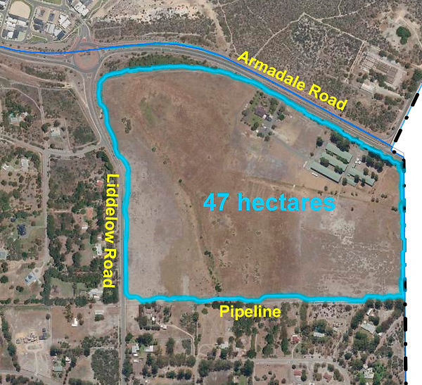
The WA Planning Commission has advertised for public comment a proposal by land developer Mirvac to amend the Metropolitan Region Scheme (MRS) to rezone for urban development the “egg farm” (Lot 709 Armadale Road) at the north end of Liddelow Road, Banjup. If approved, about 700 houses could be built on the land.
You can see the advertisement here: Metropolitan Region Scheme Amendment 1437 (Complex) - Lot 709 Armadale Road, Banjup | Have Your Say, WA! You can download the pertinent documents at that site or here: Armadale 342 lot 709
The land comprises just under 47 hectares and, apart from the residence, the old egg farm, and the associated buildings, has been wetlands, fallow, or used for grazing since the 1950s and earlier. It is currently zoned “Rural – Water Protection” and “P2” under the Jandakot Groundwater Protection Policy, like the rest of residential Banjup.
In accordance with BRG members’ resolution at the AGM of March 2024 (see here Banjup Vision | Banjup Residents), the BRG will likely oppose Mirvac’s proposed rezoning. However, the Committee seeks the views of the Banjup community before proceeding. Please email secretary@banjup.au to let the Committee know your views.
We must make our submission by 12 September 2025
Proposed Tree Protection Policy
3 July 2025
The City of Cockburn is proposing to protect tall trees within its local government area, which includes rural Banjup, Jandakot, and Treeby – see Local Planning Policy 5.26 - Tree Protection | Comment on Cockburn The City invites submissions on its proposal by 1 September.
Committee members of the Banjup Residents Group met with City of Cockburn officers to determine how the proposed policy would affect rural landowners. Our initial assessment is – not much, as follows:
1. Focus on Urban Tall Trees
The focus of the City’s proposed protection policy is on tall trees on older established urban properties, such as Hamilton Hill, that might be subject to sub-division proposals. The City wants to avoid clear felling of large blocks and ensure that development plans can preserve established trees and the canopy and character that they provide. However, the policy would also apply to rural properties.
2. Effect on Rural Landowners
Rural landowners will likely only encounter the Cockburn’s tree protection policy if they apply to erect a new shed, say, and want to cut down tall trees to make way for it. Our understanding is that the City would discuss siting the shed elsewhere rather than fell trees.
Reasonable pruning maintenance of tall trees would not require approval. Useful guidelines for pruning trees to Australian Standards are at The Australian Standards AS4373-2007 'Pruning of amenity trees' and what does it mean? - Rennie Bros Tree Services
However, removal of a tall tree for safety reasons would need to be discussed with the City. Discussions would not be arduous and approval would not be unreasonably withheld.
Removal of dead trees would not require approval (but take a photo as proof beforehand!)
3. Regulated Trees
The proposed policy would allow the City of Cockburn to declare any tree over 8 metres tall as a “Regulated Tree”, whether the landowners, rural or urban, agree or not. Just as a landowner must obtain the City’s approval before erecting a building on his land, so any removal or severe lopping of such a tree would require the approval of the City of Cockburn beforehand.
4. Location of Every Tall Tree
The City knows the whereabouts of every tall tree within the City boundaries from a “layer” within its mapping system – see the maps at Regulated Trees in the City of Cockburn (zoom into your street to reveal the tall trees in bright green).
The maps of Regulated trees will assist the City with its compliance activities, particularly when a new Development Application is submitted and it can be shown that Regulated trees have been removed beforehand.
5. No Effect on Zoning
On first reading of Cockburn’s proposed tree protection policy, it might be thought that it would be helpful in further protecting our rural amenity from avaricious land developers. However, in zoning matters state legislation trumps all local government policies. Rural landowners’ trees are best protected by state planning and environmental legislation – until the Minister determines otherwise.
6. Your Thoughts?
Your Committee trusts that you find this review of Cockburn’s tree protection policy informative.
Please let us know your thoughts on the policy and what should be the intent of the BRG submission to Council. Email us at secretary@banjup.au
Rezoning Lot 709 Armadale Road - the "Egg Farm"
16 June 2025
We understand that the WA Planning Commission has authorised the advertising of a proposal by land developer Mirvac to rezone the 47 hectares of mostly pasture at Lot 709 Armadale Road for urban development. The advertisements will likely be released for public comment in July.
To avoid doubt, this is the subject area to be advertised for an amendment to the Metropolitan Region Scheme:
A verbal presentation by Mirvac in support of the rezoning was made to the WAPC meeting on 19 February 2025. These are the main points Mirvac made as shown in the agenda paper:
-
Our [Mirvac’s] presentation to the Commission is in support of the proposed MRS Amendment.
-
We have been on an extensive journey (engagement, designing, reporting and substantiating our proposal) providing justification for the proposed MRS rezoning including the economic and social rationale and cost benefit analysis, in support of delivering residential dwellings on the subject site.
-
The Planning Frameworks are a high-level guide formulated over 5 years ago and unable to completely address the current housing crisis. Rational proposals which fall outside the Frameworks can be entertained by Govt.
-
The site is categorically unique in terms of its size (47ha), is under single landownership, absence to environmental value and importantly is able to leverage off existing & established infrastructure.
-
Conversely, the adjacent area to the west is impacted by significant environmental (vegetation) and fragmented landholdings constraints.
-
The proposal is supported by up to date engineering analysis which has confirmed Lot 709 can be fully serviced at no cost to government
-
The proposal is supported by real market economic analysis undertaken by specialist firms which confirmed residential land take-up rates and population growth in the Cockburn area have far exceeded Perth and Peel @3.5 million forecasts;
-
The EPA has confirmed the denuded nature of the site and lack of environmental assets
-
The DWER position of not supporting reclassification of the land from P2 to P3 is the same as that provided for all other recent urbanisation projects delivered/proposed within the Jandakot Mound.
-
Groundwater currently extracted by the adjacent J70 Water Corporation bore accounts for only 1-2% of the entire extraction from the Jandakot mound.
-
The Jandakot-Treeby DSP is unlikely to meet original residential yield forecasts due to the extent of environmental assets present.
The Banjup Residents Group has campaigned long and hard to preserve our rural amenity and ambience. Our members have endorsed a Vision for Banjup that preserves our safe, green haven of peace and tranquillity. You can read more here: Banjup Vision | Banjup Residents
700 residential houses on our northern border will significantly impact us. It will inevitably lead to more pressure to develop land north of the water pipeline in Murdoch Way and Gutteridge Road. However, our concerns might not be considered by the State government in its quest for more residential land, even though plenty has been already identified in the Perth and Peel Planning Framework that was updated only a couple of years ago. The Framework was originally called Perth@3.5million and sufficient land was identified to accommodate 3.5 million by 2050. Perth’s current population is 2.3 million, so there should be plenty of undeveloped land left without Banjup.
Separately but in parallel to Mirvac and with their knowledge, several landowners on Murdoch Way and Carlson Place wrote on 25 May to the Minister for Planning, copied to many others including the BRG, asking for their lands to be rezoned for urban development.

Current indications are that developers will pay $1 million per hectare for residents’ private land, regardless of the buildings thereon – they would be bulldozed anyway. Existing landowners could get better prices by selling into the residential housing market. Even if Murdoch Way were rezoned, no-one can force a landowner to sell.
We understand that the City of Cockburn will oppose both proposals for rezoning.
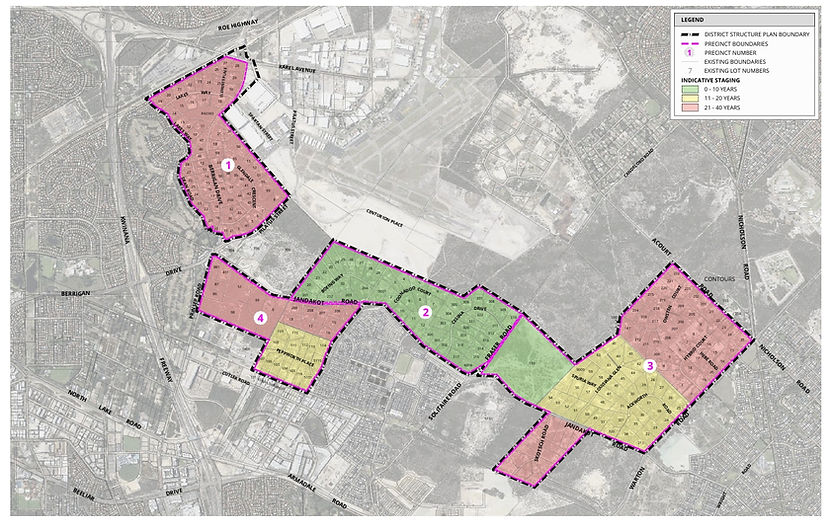
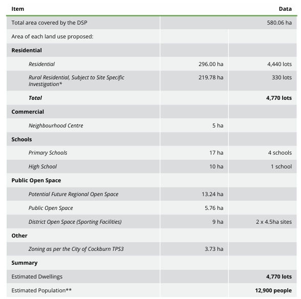
Jandakot / Treeby Structure Plan
16 June 2025
The Department of Planning, Lands and Heritage is advertising of a draft district structure plan for the Jandakot/Treeby urban expansion area. The draft documents are available at https://haveyoursay.dplh.wa.gov.au/jtdsp
Submissions close 15 August.
The structure plan shows that the developers anticipate 4,770 houses being built over the next maybe 40 years, according to the map on page 55.
Mobile Phone Blackspot Funding
17 January 2025
Mobile phone reception in Banjup is poor. The telcos seem to have forgotten us. Our only mobile phone tower was built in 2018 to bolster the reception in Atwell, not specifically to service the 420 homes in Banjup.
New funding to improve mobile phone coverage will become available soon under the Commonwealth government’s Mobile Black Spot Program. Banjup could qualify for such funding under the recently announced Round 8 of the Program.
Round 8 offers $55 million in grant funding for disaster prone locations in regional and rural Australia, to bolster community safety and enable better assistance for locals during and after emergencies.
The Mobile Black Spot Program is an ongoing Australian federal government funding program aimed at adding mobile phone reception to areas which do not have it, such as communities, transport routes and tourist destinations.
Since its inception in 2013, over 1,200 mobile base stations have been funded and a total of 1,047 constructed by Telstra, Optus, TPG Telecom (formerly Vodafone), and Field Solutions Group (FSG). Mobile base stations built under the program are funded with contributions from the Commonwealth, the network operators themselves, and in some cases, state and local governments.
Our local MP, Josh Wilson, federal member for Fremantle, has written to the BRG to nominate Banjup for funding to upgrade our mobile phone reception. He says:
“To help build a strong case I would like to invite you to tell your story about this issue, and why improving mobile connectivity is so important to you and the Banjup community.
Please provide this to my office … by 5:00pm AWST on Wednesday 29 January.“
The BRG will facilitate a reply but we need to reflect the needs and views of residents and their stories, as Josh puts it.
By Saturday, 25 January, can you write to the BRG at secretary.banjup@gmail.com to tell us your views and your “stories”?
HOWEVER, the BRG is very aware of the controversy about mobile phone towers that arose in 2016 and 2017 when many residents objected to the siting of a tower in Harper Road. Community support one way or the other needs to be clear before the BRG responds to Josh Wilson.
Note that in January 2018 the State Administrative Tribunal approved the siting of a mobile phone tower at 25 Harper Road. In its decision, the Tribunal said:
“The impact of the facility on the visual amenity of the locality was weighed against the State planning policy objectives of providing telecommunications facilities. The Tribunal concluded that overall the community benefits derived from the proposed facility was balanced with any consequential impact there might be on the visual amenity of the locality and found that planning approval was warranted subject to the imposition of appropriate conditions. Consequently, the application for review was allowed and conditional planning approval granted.”
In a few words, community benefit outweighs loss of visual amenity.
Further, the WA State Planning Policy 5.2 – Telecommunications Infrastructure says at 3.1 Electromagnetic Emissions (EME):
“The Australian Radiation Protection and Nuclear Safety Agency (ARPANSA) Radiofrequency (RF) Standard which sets limits for human exposure to RF electromagnetic fields from all sources, including telecommunications infrastructure. ARPANSA is the primary Commonwealth agency responsible for protecting the health and safety of people and the environment from the harmful effects of radiation.
Standards set by ARPANSA incorporate substantial safety margins to address human health and safety matters; therefore it is not within the scope of this Policy to address health and safety matters. Based on ARPANSA’s findings, setback distances for telecommunications infrastructure are not to be set out in local planning schemes or local planning policies to address health or safety standards for human exposure to electromagnetic emissions.”
In a few words more, objections to a mobile phone tower on health grounds will not be entertained by government.
Traffic Management in Banjup
The Banjup Residents Group has been campaigning since 2014 to deter heavy trucks and through traffic from Banjup’s roads. At almost every meeting of BRG members in the Banjup Hall we have discussed traffic and what to do about it.
In 2019, we thought that we were making progress with the Cardno traffic study that recommended several road “treatments” such as “modified T-intersections” and blisters on the through routes of Liddelow and Beenyup. We discussed this at length in the BRG meetings in the years since. However, the City of Cockburn has been reluctant to take those recommendations further.
Since mid 2023 there has been a change in personnel and attitude at the City of Cockburn. They are now more cognisant of the need to preserve Banjup’s rural amenity as mandated by Councillors in the “Banjup Preservation Principles” that include:
The intended function of the roads in Banjup is for traffic within its local area and not for traffic between outside areas and they will be managed as such.
City officers have engaged constructively with the BRG Committee to find ways of reducing through traffic. However, the City is bound by the rules of Main Roads WA that are very prescriptive about traffic management treatments.
Apparently, the recommended modified T-intersections would require extensive street lighting, kerbing, drainage, and modified property driveways along the length of Liddelow Road, at least. City officers have told Councillors that such works could cost $20 million, which would be a “grave financial impost” on the City and is three times the City’s roads budget for 2023-24.
It would be unrealistic of Banjup residents to expect Councillors of the City of Cockburn to approve such a large sum on traffic management in Banjup. Accordingly, the BRG Committee reluctantly agreed that the recommendations of the Cardno report are not appropriate and that alternative traffic management measures must be devised.
Cockburn officers liaised with the Committee to develop alternative treatments to reduce traffic through Banjup. Officers advised that Main Roads WA might favour a proposal that speeds on all Banjup streets be limited to 60 kph, except for Liddelow Road, which would be limited to 70 kph. Such reductions could divert some through traffic to faster roads.
Main Roads WA requires that “threshold statements” would need to be put in place at all Banjup entry points and would signify to roads users that they are entering a different area and should expect different road conditions, including lower speeds. Threshold statements would include not only signage but also changes in road surface and width and the planting of tall trees.
At its September 2013 meeting, the Council of the City of Cockburn unanimously approved the proposal to design measures to make Banjup a “Local Area Speed Zone”. This would see all roads in Banjup limited to 60 kph, except for Liddelow Road which would be 70 kph. Cockburn’s Traffic Manager anticipates that the slower speeds would divert some through traffic onto faster roads elsewhere.
After 10 years of lobbying the City of Cockburn, this is the first practical measure to deter traffic that they have offered and look like implementing. It may not be all we wanted but it is a first step. Besides, freeway speeds are not compatible with the rural idyllic that we are trying to preserve and promote.
The City of Cockburn put the traffic management proposals out for public consultation to all Banjup residents from 28 February to 15 March 2024. At the BRG AGM on 10 March, members voted overwhelmingly to support the proposals. The officers' report to Council will likely be made to its meeting in May 2024.
Aboriginal Cultural Heritage Act affects all rural properties
UPDATE:
The WA government has promised to repeal the ACH laws but update the previous legislation. How this might affect rural landowners in not known.
The Aboriginal Cultural Heritage legislation comes into effect on 1 July 2023 and applies to all land in WA greater than 1,100 square metres. Consequently, it affects every landowner in rural Banjup, Jandakot, and Treeby – our land areas are typically 20,000 square metres and more.
The Act, the Regulations, and the Guidelines as currently available are all substantially incomplete, so it is difficult to give guidance with any confidence. The Act, the Regulations, and the Guidelines as currently available are all substantially incomplete, so it is difficult to give guidance with any confidence. You can download each of them at https://drive.google.com/drive/folders/1OQPKvgV6HZineQjBlkTsJ7qZtELYSaSm?usp=drive_link
However, the Act says Aboriginal cultural heritage means
“the tangible and intangible elements that are important to the Aboriginal people of the State, and are recognised through social, spiritual, historical, scientific or aesthetic values, as part of Aboriginal tradition”
The Guidelines imply that, on properties over 1,100 sq metres, if you maintain existing infrastructure in a way that, over the course of 1 calendar year, involves any of the following—
(a) removing more than 4 kg of material;
(b) disturbing more than 10 m2 of ground in total;
(c) disturbing more than 1 m2 of contiguous ground;
(d) excavating to a depth of more than 0.5 m.
then an ACH authorised person must perform a Due Diligence Assessment before any works can proceed.
“Gardening” is an exempt activity but digging a 600 mm deep trench would not be.
The legislation is aimed at mining companies in the wake of the Juukan Gorge fiasco. However, its broad ambit could give activists opportunities to disrupt your rural living. Such a disruption was reported on 15 June at Port Hedland traditional owners accuse council, Water Corp of disturbing heritage site - ABC News .
An e-petition to the Legislative Council is open for signature until 20 June. You can see it at https://www.parliament.wa.gov.au/Parliament/LCePetitions.nsf/petitions/23-0018
Rural landowners might well consider that it is in their best interest to sign the petition.
Note that the Government has substantial majorities in both houses of the WA parliament.
Still No Clarity on Water Mound Review
UPDATE:
The Department of Planning has "clarified" that the Water Mound review was only to "inform the decision on the Jandakot PIA". The areas south of Armadale Road will not be affected by the outcome of the review.
At the BRG AGM on 26 March 2023, 80 members discussed the implications of the State government review of the "whole of the Jandakot water protection area, including the [Jandakot] PIA".
Enquiries by the BRG Committee of the PIA team at the Department of Planning revealed that they could not explain why the whole of the Water Mound was being reviewed – they were only interested in the Jandakot/Treeby PIA.
The Committee had spoken by telephone with Deputy Premier Roger Cook MLA who could shed no further light either.
There is no ambiguity in the announcement. If the review had been to inform only the Jandakot/Treeby PIA, then it would have been phrased as such. Instead, the government was explicit in reviewing land use on the Water Mound from the airport down to Anketell Road.
The wording of the review is clear and no accident. Government somewhere has an intention that is yet to be revealed.
Government Review of All Lands in Banjup, Jandakot, and Treeby
The State government announced on Wednesday, 21 September 2022, the outcome of 4 years’ planning investigations into future uses of 12 areas of land in the Perth metropolitan area – see Media statements - Potential for up to 76,000 new homes with resolution of Planning Investigation Areas .
You can download the 20 page report, “Perth and Peel@3.5million Planning Investigation Areas Update” at Planning investigation areas (www.wa.gov.au) (about half way down the page).
Sadly for residents in rural Jandakot and Treeby, the future zoning of their lands was not resolved; they are still under “Planning Investigation” (see page 16 of the PIA report).
Sadly also for residents in the south west corner of Banjup between Lyon and Kinley, they did not rate a mention in the report.
Alarmingly, for all residents on the water mound, the PIA Update report also states on page 16 when discussing rural Jandakot and Treeby that:
The State Government has committed to undertake an integrated and whole-of-Government strategic review of water and land use values in the Jandakot water protection area as a priority.
The review will inform further consideration by the WAPC and State Government regarding future policy settings within the broader Jandakot water protection area, including the PIA.
A ”whole-of-government” review implies that the Department of Water (DoW) will be just a participant in the review. As when the “Banjup Urban Precinct” (now Calleya) proposal was being evaluated in 2012, the Department of Planning (DoP) will be the lead agency for the upcoming review. In 2012 the DoP wanted the old sand quarries rezoned and the DoW was reduced to requiring that any water run-offs from roads were contained.
“…as a priority” could imply over the next 12 months.
The “broader Jandakot water protection area” implies all land uses in Jandakot, Treeby, Banjup, and south through Wandi and Anketell will also be reviewed (see map at the end of this email).
As we all know, governments do not start an inquiry or review without knowing the answer first. Our rural lands are under threat.
Your Committee welcomes your thoughts on how the Banjup Residents Group should respond in the short and longer terms to the state government’s announcements. Email your thoughts to Secretary.banjup@gmail.com
Apply for Garden Bore Exemption
The WA Government has mandated that from 1 September 2022, garden bores may be used only twice a week, which brings the regulations in line with the 2 day a week restriction on sprinklers using scheme water.
However, the Banjup Residents Group was successful in lobbying for exemptions for bore users not connected to scheme water and living in a bushfire prone area. All residents of rural Banjup, Jandakot, and Treeby meet these criteria. Note, though, that it is not a blanket exemption for our area: each property owner or occupier must apply for their own exemption.
The Department of Water Regulation administers the exemption scheme. You can apply for your own exemption at:
https://begroundwaterwise.wa.gov.au/garden-bore-regulation/apply-for-approval-to-irrigate-on-a-three-day-sprinkler-roster/
It is a straightforward on-line application that the Department will review manually before writing back to you.
Bore Roster Change Opposed
The WA government is proposing to reduce from 3 to 2 the number of times each week that a bore may be used from 1 September 2022. For rural landowners, this threatens the viability of the Asset Protection Zones around our houses and so exposes us to greater risks in the event of bush fire.
The BRG Committee is vigorously opposing the proposal. We have:
Met with Kwinana MLA and Deputy Premier Roger Cook to ask him to speak on our behalf to the Minister for Water, Dave Kelly.
Written to Jandakot MLA Yaz Mubarakai but he is on leave until March.
Spoken with Cockburn councillors to seek their support, which they have given, for an exemption for those not on scheme water.
Spoken with executives at DFES to clarify their position on Asset Protection Zones, which is as published on the DFES web site.
You can see more about our current initiatives here.
Kinley Road change of use rejected
On 9 October 2021, Cockburn Council rejected the application for retrospective approval of the Kinley Road "lodging house" and gave the occupiers 90 days to vacate the premises and return them to then approved use.
Transport depot at Beenyup and Gibbs given 2 years' temporary approval
On 9 December 2021, Cockburn Council gave 2 years' temporary approval for the JAG traffic sign business to continue to operate at 157 Beenyup.
Previously, on 8 July 2021 Council refused the development application. The applicant then took the decision to the State Administrative Tribunal (SAT).
It appears that there is a deficiency in Cockburn's town planning scheme that would allow any use of land in the 'Resource Zone'.
SAT directed Cockburn and the applicant to come to a mediated agreement which was put to Council on 9 December and included a 5 year temporary approval. Council accepted the terms of the agreement but gave only a 2 year approval.
Objection to Kinley Road development
22 July 2021 - The BRG submitted to the City of Cockburn an objection to the retrospective development application for a multiple tenancy hostel in Kinley Road.
Objection to 'transport hub' at Beenyup and Gibbs
27 May 2021 - The BRG submitted to the City of Cockburn an objection to the retrospective development application made by the owner of the property at the corner of Beenyup and Tapper for retrospective approval to legitimise his use of the property as a trucking depot that has been operating there for several years.